

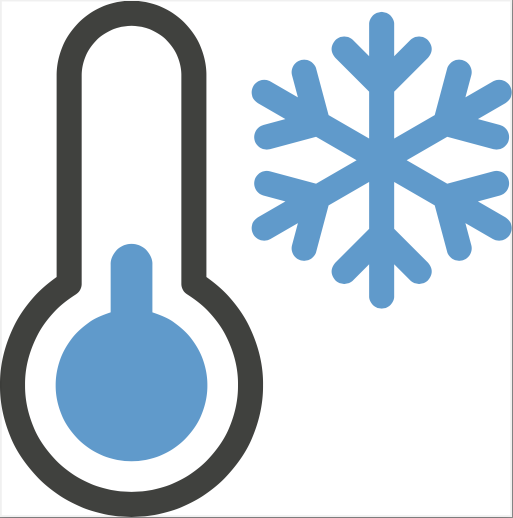
+70
°
F
+74°
+58°
Niagara Falls
Thursday, 16
See 7-Day Forecast
Featured News - Current News - Archived News - News Categories
Up to 8 inches possible for higher elevations throughout Western New York; high wind warnings in effect for parts of region
Submitted by the Office of Gov. Kathy Hochul
On Friday, Gov. Kathy Hochul urged New Yorkers to be cautious ahead of a winter storm set to impact parts of the North Country, Mohawk Valley, Central and Western New York Friday through Saturday. Areas east of Lake Ontario in the Tug Hill Plateau could see up to 18 inches of snow and winds up to 30 miles per hour. Higher elevations throughout Western New York have the potential to see up to 8 inches of snow, and wind gusts in areas along the Lake Erie shore could reach up to 60 miles per hour. Snowfall and winds are expected to result in power outages and create dangerous travel conditions during the Friday evening commute. Drivers should leave themselves extra time to reach their destinations.
“While New Yorkers enjoyed the past few days of sunshine and warm weather, our upstate regions are expecting a winter storm through Saturday, with up to 18 inches of snowfall and up to 60-mile-per-hour winds for parts of Western New York,” Hochul said. “Our agencies are prepared and ready to respond to this storm and keep New Yorkers safe. Stay vigilant, avoid traveling during hazardous conditions, and utilize “Triple Three, Triple One” – as always, it is important to monitor the latest forecast and plan accordingly.”
(In 2025, the governor launched the “Triple Three, Triple One” emergency and weather alert text system that allows New Yorkers to receive real time emergency and weather alerts and updates directly to their phones.)
These conditions are the result of a clipper-type system that will bring the heaviest snowfall across the North Country and northern Mohawk Valley regions. Winter storm warnings remain in effect across portions of the North Country and Mohawk Valley regions where the heaviest snowfall is expected. Winter weather advisories have been issued for additional portions of the Mohawk Valley, Capital Region, Mid-Hudson and North Country regions.
Strong winds are also anticipated with the clipper system for today through Saturday. High wind warnings have been issued across portions of Western New York and the Finger Lakes from this morning/afternoon through Saturday morning, due to 25- to 35-mile-per-hour winds with gusts up to 60 miles per hour. The strongest winds will be closer to Lake Erie and along the Niagara Frontier. Wind advisories have also been issued for other portions of Western New York, the Finger Lakes and Central New York. These winds are expected to cause some blowing/drifting snow adding to the threat of hazardous travel.
New Yorkers should closely monitor their local forecasts and look for updates issued by the National Weather Service. For a complete listing of weather alerts, visit the National Weather Service website.
New Yorkers should also ensure that government emergency alerts are enabled on their mobile phones. They should also sign up for real-time weather and emergency alerts that will be texted to their phones by texting their county or borough name to 333111.


1859 Whitehaven Road, Grand Island, NY 14072
Phone: 716-773-7676
Fax: 716-773-7190