
+70
°
F
+74°
+58°
Niagara Falls
Thursday, 16
See 7-Day Forecast
Featured News - Current News - Archived News - News Categories
State of emergency remains in effect statewide; New Yorkers encouraged to remain off roads in impacted areas and rearrange New Year’s plans if needed
√ New Yorkers can sign up for weather and emergency alerts by texting 333111
Submitted by the Office of Gov. Kathy Hochul
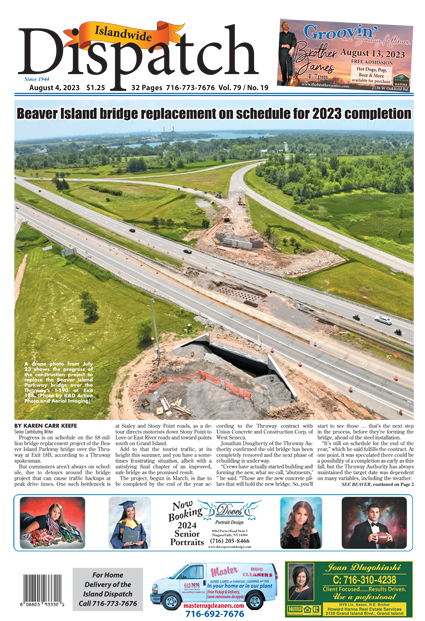
Gov. Kathy Hochul today reminded New Yorkers to remain cautious while traveling this week, as severe winter weather conditions and lake-effect snow will continue impacting the state. Lake-effect snow off the shores of lakes Erie and Ontario is expected to fall until Saturday, and while winds are expected to continue subsiding, blowing snow that creates hazardous driving conditions remains a concern, especially during New Year’s Eve and New Year’s Day.
New Yorkers, especially those in the Western New York, Central New York and the North Country, should pay close attention to their local forecasts, avoid unnecessary travel during periods of heavy snowfall, follow the direction of local authorities, and telecommute whenever possible.
“As New Yorkers make plans to ring in the New Year, I urge everyone to use caution, prioritize safety and avoid any unnecessary travel in areas experiencing heavy snow and winter storms,” Hochul said. “My administration, emergency management teams, and plow and utility crews continue to actively respond to the ongoing winter weather to keep New Yorkers safe, and we stand ready to assist impacted communities over the holiday.”
The latest forecasts indicate that areas south of Buffalo could see between 2 and 3 feet of additional lake-effect snow through Saturday, with snow falling between 1 and 2 inches per hour in the heaviest bands. Lake-effect snow also will continue to fall at a rate of 1 to 2 inches per hour off Lake Ontario in Central New York, potentially reaching the Mohawk Valley at times. The heaviest band of snow is expected to remain over the Syracuse metro-area throughout this afternoon and may re-intensify to snowfall rates of 2 to 3 inches tonight, before drifting north toward the Tug Hill Plateau during the overnight hours.
A clipper system will affect the rest of New York state on New Year’s Eve, bringing anywhere from a dusting to 3 inches of snow. While winds are generally expected to subside to the 20- to 25-mph range, this wind strength combined with the dry snow consistency will continue the potential for blowing snow that could create hazardous driving conditions, especially on New Year’s Eve. More cold air is expected to follow on Friday and reinvigorate the lake-effect bands.
Numerous winter storm warnings and watches, winter weather advisories, high wind warnings and wind advisories have been issued by the National Weather Service. New Yorkers should closely monitor their local forecasts and look for updates issued by the National Weather Service. For a complete listing of weather alerts, visit the National Weather Service website.
New Yorkers can access government emergency alerts on their mobile phones. They can also sign up for real-time weather and emergency alerts that will be texted to their phones by texting their county or borough name to 333111.


1859 Whitehaven Road, Grand Island, NY 14072
Phone: 716-773-7676
Fax: 716-773-7190